The Ultimate Island Road Trip Is 232 Miles Of Pure Coastal Paradise
Volcanoes, rainforests, beaches, and bento.
At just over 4,000 square miles -- enough landmass to swallow all its neighboring isles -- the Big Island of Hawaii lives up to its name. Driving around it is a 232-mile jaunt that you can knock out in a scant 5 hours, but let's be real: What's the point of driving through paradise in a hurry? This is a route that you could tackle in a day or a week, depending on your disposition.
The journey isn’t so much about the size of the island as it is the motion of the ocean... and the volcanoes, rainforests, curiously colored beaches, sleeping sea turtles, and monk seals. This wondrously varied landscape encompasses 10 of the world’s 14 sub-climate zones, and you’ll drive through darn near every one of them during your detour-packed circumnavigation.
It's one of the most stunningly gorgeous and driveable coastlines on planet Earth. Here are your essential stops along the way.
Editor’s note: Hawaii is currently closed to tourism due to the ongoing pandemic. If you are flying here from the mainland you will need to self-quarantine for 14 days subsequent to your arrival—at your own expense. This statewide protocol is in effect until at least September 1st. Check with the Hawaii Tourism Authority before booking any flights.

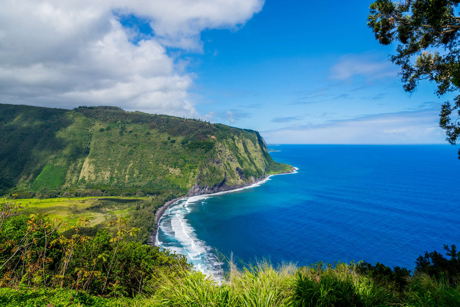
Pololū Valley & Hawi
Set the precedent for pit stops with the first of many sweeping vistas. An overlook at the road’s end here affords a dramatic view of lush cliffs kissing the ocean. To level-up the scenic bounty, take a 20 minute hike down to the gray sand beach below. From there you can gaze up and into the broad, U-shaped river valley, the northernmost of seven ravines carved into the sides of an ancient volcano now known as Kohala Mountain.
Follow HI-270 a mere 15 minute from Polulū to arrive in the supremely welcoming and colorful village of Hawi. Now home to just over 1,000 residents, it was once a bustling cultural hub long before the days of annexation. Fertile soil of the region allowed for a diverse array of crops to thrive, including taro and sweet potatoes. If you want to savor some of that flavor today, pull up a chair at the Bamboo Restaurant & Gallery where home-cooked specialties are plated in a cozy dining room. In 1758, King Kamehameha I, was born just beyond what is now the town center of Hawi. Thirty-Two years later he had unified all of the islands into a single kingdom. A statue erected in his honor stands just up the road in Kapaʻau.

Makalawena Beach
Everywhere you look, Hawaii showcases gorgeous swaths of sand, much of it devoid of crowds. But Makalawena offers exceptional beauty and solitude even by Big Island standards. That’s because it requires a mile-long hike over hardened lava rock to reach, with no signs pointing the way. But if you look for the road to Mahai'ula Bay (between the 90 and 91 mile markers on HI-19) you can follow it to the end, where you’ll find picnic tables, restrooms, and an already swell beach that sometimes hosts endangered Hawaiian monk seals. From here you can take a trailhead, or just follow the coastline to this secluded stretch of turquoise water lapping up against white sand.

Keauhou and Keauhou
A dozen miles south of Mahai'ula Bay, HI-19 takes you through Kailua-Kona -- the primary population center of West Hawaii. Here you can sip on craft beer from local breweries including Kona and Ola Brew Co, or feast on an impossibly fresh poke bowl at Umeke’s Fish Market. But don’t get too tied down: You’ve got to make it to Keauhou in time for sunset. The small coastal village is renowned for its nightly manta ray viewings, and a number of local purveyors provide tours. Book yours with Anelakai Adventures: The family-run business is the only one using a motor-less outrigger to bring guests up close and personal with the massive maritime marvels. You’ll snorkel right alongside dozens at a time, some with wing spans as wide as 16 feet from end to end.

Kealakekua Bay
Just before the town of Captain Cook, take a slight right off Hawaii Belt Road and follow state highway 160 down to Kealakekua Bay. Home to a Marine Life Conservation District, this tucked-away community boasts some of the state’s best snorkeling. Stare out over the natural cove and you might notice a small white obelisk gracing the opposing shore. This is a monument built to honor British explorer James Cook, the first Westerner to "discover" these islands, which he tried to name after the Earl of Sandwich. After an ill-advised attempt to kidnap Kalaniʻōpuʻu, the ruling chief of the island, he met his untimely demise here in 1779. On the eastern edge of the bay you can also check out a sacred temple dedicated to the Hawaiian god, Lono.

South Point
Follow HI-11 for an hour south through Kona coffee country. Signs along the road denote places where you can stop for tastings, if you’re in need of an added pep. As you round the southern perimeter of the Kaʻū Forest Reserve, keep your eyes peeled for signs to South Point Road. Turn right onto it and follow the gently sloping pavement for 10 miles towards land’s end. This isn’t just the southernmost point of the island -- it’s the southern terminus of the United States. From here you can follow a dirt road to a trailhead for Papakōlea Beach. It’s the start of a three-mile hike that skirts the shore leading to the country’s only stretch of green sand.
MORE: Get even more kaleidoscopic at the world's most colorful beaches

Punalu'u Beach Park
By now you’ve already encountered pristine shores speckled with gray, green, and white sands, so why not try jet-black on for size? Just nine miles down the Belt Road from South Point, Punalu'u Beach's midnight hue comes from ancient lava flows pounded down by the surf over eons. But if this is all just a bit routine to you, maybe you’ll draw excitement instead from the endangered Hawksbill and green sea turtles (known locally as honu) lounging about. The docile amphibians are almost always found here during daylight hours, soaking up the sun.

Hawai’i Volcanoes National Park
Now heading north on HI-11, you’ll soon pass into Hawai’i Volcanoes National Park, home of two of the world’s most active eruptors: Kīlauea and Mauna Loa. Up until 2018 you could drive right up to the rim of an active crater and spy cauldrons of lava gurgling up from the earth’s mantle. Ever since a series of massive eruptions throughout that year, however, Pele has been quietly resting, though the Hawaiian goddess of fire will undoubtedly awaken at some point in the future.
But in the meantime, after exploring the park you can taste some of the wines she helped create with her incredibly fertile soil. The small town inside the park is aptly named Volcano. And its eponymous winery infuses local ingredients such as guava and macadamia nut honey into small batches of grapes fermented on-site. Tours are available every day of the year, except for Christmas.
MORE: Before you head to the park, read up on its current restrictions

Hilo
Hilo is the Big Island’s largest city, and it's steeped in enough history to rival its overgrown tropical foliage. Originally settled by Polynesian wayfarers over 900 years ago, the seaside community was the primary port of the islands long before that title was taken over by Honolulu. Grab yourself some musubi and fish cakes to-go from Hilo Lunch Shop -- a legendary no-frills okazuya on the outskirts of town -- and truck it on over to Carlsmith Beach Park for a picnic alongside a crystal-clear lagoon. The warm and inviting waters, not to mention the hovering honu, might beckon you for a quick snorkel and swim.

Akaka Falls and Paauilo
Heading north on HI-19, the landscape abruptly evolves into a tropical rainforest. This is Pepe’ekeo scenic drive, perhaps the most famous tourist route on the Big Island. Along it you’ll take in bright and bountiful flora on either side of the roadway. Views of Onomea Bay will soon appear over the passenger side of your vehicle. Remember to keep your eyes on the road and don’t miss signs for Akaka Falls State Park once you make it into the small town of Honomu. Turn left and it’s a four-mile drive up through cow pastures and into a well-marked parking lot. Getting to the 422-foot falls requires a quick and easy half-mile hike along a well-established trail. This is one of the natural wonders of Hawaii’s windward (east) side, also known as the Hamakua Coast.
After again returning to the Belt Road, you’ll hug the shoreline while traveling in a northwesterly direction. If you feel like you haven’t gotten enough beach time over the past several days, stop at Laupāhoehoe Beach Park. It’s a good way to break up the 26-mile jaunt from Akaka to the bustling metropolis of Paauilo (pop. 595). Blink and you might miss it, sure. But you certainly won’t want to miss the bento rolls at the Paauilo Store, formerly known as Earl’s Snack Shop. This unassuming eatery and market is known for overstuffing Spam and Korean chicken into seaweed-wrapped flavor bombs.

Waipio Valley Overlook
From here HI-19 only has 15.4 miles left to offer. Before you get to its epic conclusion you’ll pass through Honokaʻa, an historic 19th Century sugar plantation town. That’s when you know you’re nearing one of Hawaii’s most sacred sites: Waipio Valley. The end of the road serves as its unobstructed lookout point. One mile across, five miles in length, and encased by 2,000-foot cliffs on either side, they call it "The Valley of the Kings." This was the boyhood home of King Kamehameha I, and for centuries it remained an epicenter for political and religious life throughout the kingdom. Although there is actually a road that descends to the beach from here, it has been deemed one of the steepest streets in the world. You will not be allowed down without a four wheel drive vehicle. Plus, the native Hawaiians who still live here today aren’t too keen on having you show up in their backyard. So pay your respects from afar and get ready to turn around and do it all over again -- in reverse.